Jordan Dunn
Jordan Dunn
Nepal 2019
VIEW FINAL REPORT
Namastē! I’m a Belmont graduate traveling to the Himalayas in Nepal. There I’ll be working in conservation & economic development—giving back to the nature that has given so much to me while learning about the culture of local peoples like the Sherpa. All to one day create an expedition organization that invests in local communities. Read More About Jordan →

The Finale of My Everest Journey

Rough Conditions
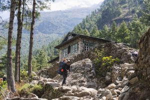
After Phortse the conditions of each village continued to worsen. Dingboche, Lobuche, and Gorak Shep were all impoverished communities filled with makeshift buildings and isolated from anything other than tourists seeking to reach Everest. The prices of even the simplest commodities increased significantly as village’s became more remote and higher in altitude. In Gorak Shep, the last village before Everest Base Camp, there is no fresh water other than bottled water, which costs $4.00 per bottle. Buildings were fashioned out of nothing more than thin sheets of plywood and sheet metal for roofs. Electricity relied entirely on solar energy, meaning cloudy days resulted in blackouts. There was no plumbing or running water, so waste was collected over time and had to be carried down the trail every so often for disposal. During the night, even at the end of May, temperatures were as low as 10ºF and winds blew incessantly. It was an experience of contrasts, as the conditions were absolutely dreadful, but the mountain scenery was simply stunning.

The foggy and windy trek from Phortse to Dingboche.

The small and isolated village of Dingboche. From this point on I had no outside contact due to lack of cell or satellite reception.

Arriving in Dingboche. It was not as deserted at Phortse, but still an eerily small and foggy town.

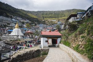
An overhead view of Dingboche with Ama Dablam in the background. You can tell that it is surrounded by mountains on all sides, making it quite disconnected from the rest of Nepal.

An unnamed peak shot from my teahouse window in Dingboche during the afternoon fog.

The village of Lobuche. This is one of the two villages that are abandoned during the off-season for trekking. Only one or two locals stay to maintain the property year-round.

The small settlement of Gorak Shep (to the left) was actually there original Everest Base Camp until it was shifted closer to the Khumbu Ice Fall (the small white patch of ice to the right). It is now the highest elevated settlement in the world.

Reality versus the Imagination
These conditions were temporary for me, but for the local Nepali people… this was their life. Crumbling buildings, trash everywhere, no running water, cold conditions, lack of resources, and the constant smell of feces. It may be easy to romanticize the idea of living in the remote mountains, surrounded by beauty and farming in an environmentally sustainable manor, but the reality of it is dark, difficult survival. Most of the people who live in these regions, wish to leave.

An up close view of Gorak Shep, which is composed of about 5 or so buildings made of plywood and sheet metal.

An example of the rooms at higher altitude. Most had very thin plywood walls and one lightbulb (which only sometimes worked).

Arriving at Base Camp
Of course, our final destination made the difficult journey worth every bit of trouble. After 9 days, over 100 miles, and 8,000 feet of elevation gain, we arrived at Everest Base Camp. Walking alongside the Khumbu Glacier as it cracked with a thunderous roar, surrounded by nothing but Mars-like fields of rock, and looking in every direction to see towering snow covered peaks—this was a surreal experience. We walked up the icy trail to a large monument dressed in Buddhist prayer flags with a small sign that read “Everest Base Camp – 5,364 meters.”

A memorial built to Rob Hall, the head guide of expedition that became known as the 1996 Mount Everest Disaster. A blizzard hit the summit, costing Hall’s life along with the lives of seven others.

Walking on top of one of the lower sections of the Khumbu Glacier on the trek to Lobuche.

The sign pointing out which way to Everest Base Camp. Without it the trail would be impossible to navigate.

Walking alongside the Khumbu Glacier, the highest glacier in the world.

The otherworldly landscape of the Khumbu Glacier as it stretches 15 kilometers alongside Nuptse and to Everest’s base.

Me posing in front of the Khumbu Glacier – only mere miles from the foot of Mount Everest.

A closer view of the Khumbu Glacier, which roared with loud cracks from ice shifts as we walked alongside its massive frame.

The camp was beautiful. Sitting atop the Khumbu Glacier, dusted in snow, and covered in bright yellow tents, it had an energy unlike any other place I have ever been. This was the epitome of exploration. Home base for the world’s bravest and most motivated climbers. We could stare straight ahead to see the Khumbu Icefall—the deadly, crevasse-filled gateway to Everest—only a football field away. From there it was easy to see the route, as it stretched between Nuptse and Everest’s Eastern ridgeline, up to the South Col (the lowest point between Everest and Lhotse). It was as though I could simply start walking in that direction and find myself on top of the world in no time at all. The reality, however, is much more difficult.

Our first clear view of Everest Base Camp. While the peak of Everest is not visible from this point, you can see where the Khumbu Icefall leads to the top (far to the left).

The bright yellow tents of Everest climbers serve as the quintessential landmark of EBC.

Because Everest Base Camp is situated on top of the Khumbu Glacier, all structures must be moved every five days or so to account for changes in the shape of the glacier itself.

My final arrival at Base Camp! It was a long and hard 14 days!

The whole crew pictured by the flag adorned monument for Everest Base Camp. American, Australian, English, and Nepali climbers all together!

Celebrating our accomplishment of making it to EBC together.

Our team congratulated each other, hugging and shaking hands, then took a number of photographs to commemorate our achievement. Standing in front of Everest revealed just why this mountain so deeply captures the world’s imagination. It is the embodiment of man versus nature. It is the quintessential example of humankind’s thirst for adventure. And it is the ultimate shrine to human curiosity. There is something about the unknown, the dangerous, and the mysterious parts of this earth that attract the human spirit. Perhaps it is admiration. Perhaps it is madness. Nonetheless, people will always climb mountains and Everest will always be a landmark achievement for any person that attempts it.

Kala Patthar (or Kala Pather) is the only location from which the peak of Everest is visible for trekkers. It is a small mountain (really more of a large, steep hill) that reaches 18,500 feet of elevation. It’s name means “Black Rock.”

Pumori in the morning glow while our team hikes toward Kala Patthar to catch a sunrise view of Everest’s peak. Its name means “Little Daughter” and was names by George Mallory—the first climber to attempt Everest in 1924.

The golden sunlit face of Pumori’s south summit.

Me after successfully summiting Kala Patthar. Standing tall at 18,500 feet!

Beginning the journey back home after completing Base Camp.

Everest’s Relationship with Nepal
For the last half century, Everest has been the driver of change in Nepal. There is a reason it is pictured on all currency and every Nepali brand seems to have ‘Everest’ somewhere in the name. Everest is Nepal’s currency. It is Nepal’s brand. People respect it, fear it, and celebrate it.

A sunrise view of Everest (the tall black peak to the right). This is the best view of its peak within trekking distance, as Everest is surrounded by other mountains including Nuptse (right) and Khumbutse (left).

Thanks to the international exploration of Everest, Nepal established a friendly relationship with the Western world long ago, ensuring it would never be conquered. Instead, it has profited from a mutually beneficial unwritten contract—the West can explore as long as Nepal can make money off of it. This has led its cultural, economic, and social diffusion. Nepal has taken what it likes from the West and left what it dislikes, making significant gains in overall development… thanks to the allure of the mountains. Now it is up to Nepal to take the next step in its growth.

Many successful (or unsuccessful) mountaineers fly back to Lukla via helicopter because making the 5 day trek back down after summiting Everest is the last thing on their mind. Helicopters are also used for emergency evacuations due to injury or altitude sickness.

Much to Be Done
One of the largest problems for mountain communities in Nepal is isolation. Mountain residents lack connection to the rest of the country and the world. Apart from satellite WiFi, they are separated from all other civilization by days of trekking across harsh and unforgiving terrain. However, locals and foreigners alike are against the building of roads throughout the region. They believe it would destroy the nostalgia of its primitive by-foot-or-yak-only transportation system and the adventurous feel of being in a remote place. While this is absolutely true, turning away from infrastructure growth and investment in these villages will result in the continual stunting of Nepal’s growth and a perpetual reliance on one industry—tourism.

Roads must be built to connect the people of Nepal. Towers must be built to transmit reliable communication. Schools must be built to educate students for a more skilled workforce. Hospitals must be built to make for a healthy and strong people. Businesses must be built in order to pull the region out of poverty and into the developed world.

The massive valley of Pheriche is a major transport route and a perfect candidate location for building a road. It stretches from Lobuche nearly all the way to Phortse.

There is a way for Nepal to grow, while simultaneously preserving its culture and environment. That is the purpose and ultimate goal of my next assignment—working in environmental conservation in the remote mountainous region of Annapurna. There I will explore the possibilities of a middle ground between economic growth and environmental sustainability.

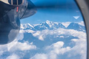
Boarding the flight back to Kathmandu from Lukla—the official end of our alpine trek. We actually trekked to a higher altitude than this plane flew.

The Dark Side of Everest

Following Namche Bazar, the environment changed quite drastically. Villages became more remote, access to common utilities was rare, and the climate more unpredictable.

To Phortse
We embarked on a 7.5 mile trek to a very small village called Phortse. This journey took us on a wide dirt path that winded alongside the edge of massive Himalayan hills and overlooked a deep valley below. We passed many Buddhist stupas (domed monuments) and walked through tiny villages with no more than three buildings. At one point, we even encountered an elderly man named Pasang Lama Sherpa, who for years has dedicated his time to maintaining the trail that connects all of these remote villages. Now too old to do the work himself, he spends his time raising the necessary funds for others to care for the trail. He sits in a small chair at a table along the trail, accompanied by a large sign that explains his story in broken English and a log book where those who donate can write their names. Given how widespread the trail’s use is by both tourists and locals alike and its sheer necessity in connecting a multitude of otherwise isolated villages, his work is instrumental in keeping the Khumbu Region economically and socially healthy.

The long winding trail from Namche Bazar to Phortse.

A Buddhist Stupa against the blue-tinted south face of Nuptse.

Pasang Lama Sherpa—the keeper of the trail to Everest.

The sign explaining Pasang Lama Sherpa’s story and asking travelers for a small donation.

Ama Dablam
After many hours of following the rocky ups and downs of the hillside trail, the towering beauty of Ama Dablam came into full view. For the remainder of our journey to Everest Base Camp, this gorgeous mountain would keep us company. It is by far the most stunning massif in the Himalayas, much more attractive than Everest’s pyramid peak. A steep rising face at 22,350 feet, its name translates to “Mother’s Necklace.” The dual peaks resemble a mother (the larger peak) wrapping her arms like a necklace around her baby (the smaller peak). Although shorter than Everest in elevation, Ama Dablam is an extremely technical mountain and regarded as a jewel of the Khumbu region.

The open Himalayan landscape revealing Ama Dablam in the distance.

The pinnacle shape of Ama Dablam’s north summit as seen from Kala Patthar, near Everest Base Camp.

Ama Dablam’s eastern face, take from my window in our Dingboche tea house.

Long Way There
As we followed the winding trail and walked alongside terrifyingly steep cliffsides, the terrain opened up for us to see deep into the Himalayas. At one point we were able to catch a full unobstructed view of Phortse—our next destination. The small village sat peacefully tucked into a hill and shrouded by the summer haze. There were multiple moments during our trekking that we were able to visually see just how far we’d come and how far we still had to go. These moments demonstrated just how small we were compared to the vast Himalayan landscape. We would peer across miles of rough terrain to see a tiny dot on a hill that was our next destination. Looking at Phortse was a humbling realization that it would be a long way there. We would have to descend deep into a valley 650 feet below, cross the Dudh Koshi at its most narrow point, and ascend another 1,000 feet up before arriving at the small village. It was by all means a grueling process.

Click here for a short video of the distant path to Phortse.

The village of Phortse tucked into the hills and in the shadow of the Nuptse ridge-line.

Arriving at Phortse
After many hours navigating the rocky terrain, we stepped out of the dense forest and into the village of Phortse. What we saw was shocking. Unlike Phakding, Namche Bazar, or any of the smaller villages we previously passed through, Phortse was entirely deserted. It was quiet, still, and barren.

As we walked up the hillside and through the center of the village, the only audible sound was the eerie howling of the cold wind. The afternoon fog settled just as we arrived, and nothing could be seen beyond the hillside’s sharp drop off into the valley below. The already small town, home to only about 100 or so people, was completely empty, cold, and quiet. Why? The answer is simple… Mount Everest.

Click here for a short video of my eerie arrival into Phortse.

Arriving at Phortse. Ram leads us down a rock path through the center of the barren village.

A small Buddhist stupa made from old rocks at the base of Phortse.

A duplex-like cottage at the entrance to the Phortse village.

Phortse’s Story
While Namche Bazar and other places were quite ethnically diverse, Phortse is a 100 percent Sherpa village. It is also off the main path used by trekkers and transporters to get to Everest Base Camp, making it a fairly isolated settlement and an accurate depiction of an authentic Sherpa village. At first glance one might assume that the village survives solely on farming; however, a far different industry sustains Phortse’s population—mountaineering.

Because it is entirely composed of Sherpa, nearly all men who are physically able work as high altitude porters or guides for Everest expeditions. I mentioned in an earlier blog that I had not encountered any Sherpa on my journey. This is why. They are all gone… working with climbers from around the world on the face of Everest. And the month of May is prime time. Many climbers dream of summitting in or around the last week of May both for reasons of weather and nostalgia (the first summit of Everest took place on May 29, 1953). Villages like Phortse feel the brunt of that, as inhabits work to make the dreams of international climbers come true. Phortse was empty because all of its people, men and even some women, were risking their lives on the 29,000 foot peak of Everest.

Looking downhill over the entire village of Phortse.

Taking a Walk in Phortse
I decided to take a walk throughout the village to see for myself how the Sherpa lived. In a matter of minutes it was clear—they live in extreme poverty. Homes are made of loose rocks piled into walls and covered with mud, pieces of stone or sheet metal are used for roofing, and much of the infrastructure remains damaged from the 2015 earthquake. At the top of the hillside lies a large Buddhist monastery, still being rebuilt after the four year old earthquake. Near it is an abandoned white tent that reads “German Red Cross” with the remnants of emergency supplies lying around it. It was a rather bleak picture, and one that revealed just how difficult living in the Himalayas actually is.

A small home in the center of Phortse.

An outhouse made of loose rocks, mud, and stone shingles.

The Buddhist monastery at the top of the hillside.

The monastery still had wood scaffolding around it from the rebuilding process following the 2015 earthquake.

Buddhist prayer wheels that surround the monastery. It is customary to walk around them clockwise and spin them as you pass.

A German Red Cross tent leftover from emergency relief following the 2015 earthquake.

A small Buddhist monument near to the monastery.

An outhouse where the locals use the bathroom.

The reality of using the bathroom in the mountains of Nepal—sheds are built slightly above ground and waste accumulates underneath. It is extremely unsanitary.

Positivity Despite the Circumstances
Our team happened to pass through Phortse during Buddha’s birthday, a day of celebration for the village. I saw many elderly couples and groups of women carrying large baskets of treats and hurrying up the steep village pathway to the monastery doors. Buddhist monks stood at the entrance welcoming all who came by. I wanted so badly to speak to the Sherpa people, but none of them seemed to know English. Not to mention, Nepali people are often reserved when approached by Western strangers and I was no exception. Regardless, I made my way up to the monastery and peaked inside. I saw children running and playing, mothers preparing food, and grandparents laughing together. Even with most of the village gone thanks to Everest, families still found joy in celebrating together.

A glimpse of a Buddhist monk as he walks home from the monastery in Phortse.

A young boy runs inside the monastery to join the other children in celebrating Buddha’s birthday.

Children playing inside the monastery while their families prepare food inside.

Meeting the Sherpa
As I walked back downhill and passed through a small arch that leads to the monastery, I encountered an older man with his daughter-in-law and her baby. The man surprisingly smiled and greeted me in English. His name was Angtshering Sherpa (Nepali people’s last names are always the name of their ethnic group). He explained to me that the reason for the celebration was Buddha’s birthday and that all those who were not on Everest were celebrating. When I mentioned that I was trekking to base camp, he shared that he was once an Everest guide himself and that he had actually summited the mountain three times. He shared that he enjoyed the job for many years, however it was quite difficult never knowing if you would return home again. But in terms of pay, no other opportunity could rival mountain guiding, especially in a village as small and remote as Phortse.

The archway leading to the monastery—where I met Angtshering Sherpa.

Angtshering Sherpa, his daughter-in-law, and her baby. He has summited Everest three times.

Angtshering Sherpa’s granddaughter. Her face appears to have small remnants of frostbite.

Reliance on Everest
After speaking with Angtshering, I returned to the tea house with some burning questions for our guide Ram. He explained to me that generally all of the men in Phortse, and villages like it, serve as high altitude guides and porters on Everest. In fact, even the man who owned the tea house where we were staying was a guide. At that very moment, he was on his way to summit Everest for the tenth time in his career. His son was on Everest was well, serving as a porter. Villagers in the remote Himalayas rely almost exclusively on income from the mountaineering industry. However, that does not mean that they prefer it that way. Ram explained that although Everest mountaineering is the dominant industry, many dream of doing something else with their lives and careers. Unfortunately, because of the lack of economic alternatives, they must choose between agriculture or mountaineering.

The sunrise view from our teahouse in Phortse—looking toward Kongde (to the right).

The Reality of the Mountaineering Industry
Of course, mountaineering pays far more than agriculture, but still less than one might expect. The typical Sherpa guide for Everest makes the equivalent of $3,000 to $5,000 USD for an expedition and only participates in one expedition per year. After subtracting out the costs of clothing, oxygen tanks, and other gear to make the expedition possible, this is a rather meager salary. For comparison, Western guides on Everest make approximately $50,000 per expedition. Of course, the cost of living is much higher in the West, but living in a remote place like Phortse does not come cheap. One kilogram of salt in Kathmandu costs only 25 rupees, while in Phortse it can cost as much at 200 rupees—eight times the price. Because of the mediocre pay in comparison to their Western colleagues, high expenses, and high cost of living, Sherpa mountain guides in Phortse still live in general poverty, risking their lives constantly just so they can provide for their families.

An early morning shot of Phortse’s vast farmland with Thamserku in the distance.

Thamserku from the patio of our Phortse teahouse.

The Core Problem
The problem is simple—these remote villages need economic alternatives. And the only way for that to happen is through economic growth.

In speaking with our assistant guide, Surya, I asked if he enjoyed taking part in Base Camp treks. He said yes. Then I asked if he could do anything in the world for a living, what that would be. He said he would love to be a teacher. But to do so, he would need education from a university, something that is extremely rare and nearly impossible to obtain in the rural areas of Nepal.

The truth is that the Nepali people have dreams as big as anyone in the world, but their circumstances prevent them from being able to make those dreams a reality. Phortse revealed this to me. While the Everest industry has brought a great deal of development, growth, and jobs to the Khumbu region, it has also created an economic system that is one-dimensional. If you are born in the Khumbu Region, and especially in a remote Sherpa community, chances are that you will find yourself working on Everest one day. Otherwise you will have to accept your fate as a poor farmer.

The Mountain Economy

The Growth of the Khumbu Region
During my time in Namche Bazar and the journey to our next destination—Phortse—Ram was a fountain of knowledge for all of my burning questions. As I spoke with him, I slowly gained a better understanding of the economic system within the mountains. Most of my prior knowledge rested on research of the Everest economy, but the economy at large poses a much more complicated problem.

Wise ole Ram.

A significant portion of the mountain region relies on tourism. The earliest expeditions to the Himalayas brought an influx of money, as British, Swiss, and other foreign climbers needed food, lodging, guides, and porters. Over time, as global transportation became more inexpensive and widespread interest in trekking grew, so did the demand from tourists for goods and services in the Khumbu Region. Tea houses, shops, guiding companies, and even entire towns grew out of the influx of trekkers seeking stunning views and climbers summiting the world’s most alluring peaks. As a result, a region that once was filled with quiet, isolated, farming communities, grew rapidly into a hub for tourism.

This growth, however, did not come easily. Development in the Khumbu Region is difficult due to the high expense of transporting goods into the mountains. The entirety of civilization past Lukla is connected via a series of trails—none of which are paved. The same trails we used to trek to basecamp. There are no roads, no cars, and no motorbikes. The primary form of transportation is by foot. For this reason, economic growth and the movement of people and products is extraordinarily slow and remarkably expensive. In response, people have adapted by using makeshift methods for development. For example, buildings are fashioned only out of local stones that are hammered into shape and lumber carried up the trail. Only the most expensive structures use concrete, which is flown in via helicopter. These challenges have caused slow development across the mountains, with luxuries like electricity and plumbing hitting many areas only recently. Regardless, the growth inspired by tourism has been extraordinarily beneficial for the mountain communities, revitalizing what was once isolated, poor farming villages into hubs of activity for global travelers.

A man hammers local stone into the correct shape as he builds this wall.

Helicopters are used to fly in heavy materials like concrete or wood. They are constantly in the air throughout the base camp trek—either for cargo, sight seeing, medical emergencies, or transporting Everest climbers.

Tourism in the Mountains
The problem, however, is that tourism is a seasonal industry. As soon as the downpour of the monsoon season arrives, everything changes. Locals close up shop, leave the mountains, and head to Lukla, Kathmandu, or their home villages for the summer. There, they continue working, but in the underlying industry that permeates all of the mountains and much of Nepal—agriculture. An astounding 27 percent of Nepal’s GDP comes from the agricultural sector. People in the Khumbu Region typically grow potatoes or cabbage, as the high altitude prevents much else. The only other industry within the mountains is animal husbandry, particularly of yak and mule for transport.

A small cabbage farm near Phakding. Cabbage and potatoes are everywhere across the Khumbu and comprise the majority of it resources.

The animal husbandry business is huge in the mountains. Mules are often used to transport heavy items like propane, water, etc.

A mule transporting water down-mountain to some of the more isolated villages.

Horses are also sometimes used, although more for riding than cargo. Nepalis often decorate them with beautiful colors and Tibetan designs.

The other backbone of the Nepalese transport economy is yaks, cows, and a mixed breed of the two called gokyo.

A yak carrying what looks to be cement up to the high Himalayas.

Farming and animal husbandry are not nearly as lucrative as the tourism business. For this reason, many people go into the tourism industry in order to make enough money to support their families and afford the high cost of living that comes with being in the mountains. This means working as a guide for trekkers, opening a tea house, or becoming a shop owner. Unfortunately, all of these professions take upfront capital or extended experience, and in the mountains there is only one way to gain capital or experience in the mountains—becoming a porter.

The Porter Economy
The porter economy is perhaps the most visible profession across all of the Khumbu Region. Simply put, when yaks or mules are unavailable, porters are used to transport cargo across long distances by foot. In essence, they are the FedEx men of Nepal. Everywhere in the Khumbu Region, men lug massive loads on their backs across miles of rough terrain. There are two major types of porters: those who carry gear for tourists and those who transport goods for people and businesses.

A porter carries the duffel bags of tourists down mountain toward Namche Bazar.

Massive boxes in transit from Lukla to another mountain village on the back of a Nepali porter.

Porters for Goods
Porters carrying goods typically transport large loads of water, food, wood, and other products used by tea houses, shops, and homes. This is perhaps the hardest job across the Khumbu Region. There is no limit to how much one can technically carry, and they are paid by kilogram of weight—incentivizing them to carry as much as possible.

A porter in the Khumbu Region is typically paid about 65 NPR (Nepali Rupees) or $0.60 for every kilogram of weight carried per day. Many porters carry up to 80 kilograms for two days (which is 175lbs), meaning they would take home about 10,400 NPR or $93.00 for the total journey. Would you accept $93.00 for two days of carrying 175lbs on your back?

A porter carrying a large load across one of the many suspension bridges in the Khumbu.

The terrain, weather, and wind is difficult enough trekking. Imagine carrying nearly 200lbs of cargo.

Unfortunately, serving as a porter is quite seasonal, meaning that most porters work about 6 to 8 months out of the year. Assuming one was able to manage two of these $93.00 trips per week for 8 months, they would bring home 665,500 NPS or about $5,990 per year.

Given that the approximate average wage in Nepal is about 361,450 NPR or $3,240 per year, this seems like a good salary. However, the cost of living is substantially higher in the mountains, meaning much of a porter’s salary is taken up in food and housing. Ultimately, it is a difficult life, but it is the best way to start out a career in the lucrative business of tourism. Serving as a porter is one of the only decent-paying jobs available for a young low-skilled Nepali in the region. Unfortunately, there are more willing porters than there are jobs, making it a competitive industry. The most competitive, however, is serving as a trekking porter.

Porters have difficult lives. They tend to be younger due to the strength and resilience necessary for the job.

Porters for Trekkers & Tourists
Because many trekkers do not want to (or are not able to) carry all of their own gear, they hire porters to transport a duffel bag of supplies from village to village ahead of them. While it may seem nearly inhumane to make someone carry loads of your own gear across rugged Himalayan terrain, most trekking organizations carefully place weight limits on duffel bags and pay their porters significantly more than private businesses (how much I’m unsure). Trekking porters also receive free accommodations in tea houses along the trek as long as they purchase their meals at the tea house—a great deal!

My team’s duffel bags had to be set outside our doors every morning before 7:00am to ensure the porters had time to set up.

Porters working for trekking agencies usually carry two duffel bags which are 12kg each, plus a small bag for themselves. Total they should carry no more than 30kg—a stark contrast from the 80kg of businesses.

For these reasons, porter jobs for trekking agencies are far more coveted. In addition, it is a great way to meet people from around the globe and travel through the mountains. At the end of our trek, the entire team paid for our porters’ dinner. We were able to sit with them and (attempt to) communicate with them. Most were quite young, but extremely grateful for the opportunity to work with us. It was a special moment to see their faces all light up when we surprised them with heaps of Mars Bars for dessert!

A porter carries hikers’ large duffel bugs up toward Everest Base Camp.

Two young porters crossing the shallow section of the Dudh Koshi on their want to Lobuche.

Many porters begin as young as 15 or 16 to develop the skills and strength necessary to do the job. Ours were anywhere from 16 to 21 years of age. (Note: Nepal measures age by how many years you’ve lived through, not how many full years you have been alive. The New Year is technically everyone’s birthday).

Porters’ Methods
Rather than carry items by hand or on a pack, porters use ropes to tie two duffel bags together and fashion a large strap that goes over their forehead like a bandana. When worn properly, this bandana-like strap allows the majority of the weight to rest on their head, distributing throughout the spine and down to the legs—rather than solely resting on the back like a regular pack might. Whether or not this is truly better for one’s health I am unsure, but it seems to be the standard practice in Nepal.

Wicker baskets are often use in order to easily add or subtract items from a Porter’s load.

Headbands are attached to ropes that run throughout the load to distribute the weight down the spine.

Many porter’s also carry small poles during their journey. These are used to set the weight of their load on while while they rest, allowing them to take a short breather without removing the headband and load itself.

Porter to Assistant Guide
Depending on their level of experience and education, Nepalis work as trekking porters for 5 to 7 years before being promoted to the role of assistant guide. Assistant guides work under an older, more experienced guide who knows the region and trails extremely well. It is important that assistant guides have some knowledge of English and ample experience trekking throughout the mountains. They aid the trekkers by leading the way during treks, answering questions, ordering meals, filtering water, and many other things. It is a hard job, but one that is much more enjoyable than working as a porter. Our assistant guides—Surya and Biru—were both in their late 20s with ambitions to further their knowledge of the tourism industry. Most of all, they were a deeply important part of the team and became much like family to us.

Left to right: Ram, Biru, and Surya. They demonstrated the gold standard of guides and assistant guides.

Nearing Everest Base Camp, a porter lugs his load across the rocky terrain that runs beside the Khumbu glacier.

Assistant Guide to Guide
After many years working as an assistant guide, some are promoted to guide. This is the best job one can have in the tourism industry as you are normally quite well respected, know many people throughout the communities in which you trek, and are paid fairly well (by Nepal standards). Our guide, Ram, has been working for the same trekking agency for 25 years, earning him a reputation as one of the best, wisest, and most enjoyable guides one can have. He lives especially well for himself because although he works in the Khumbu Region, his home is back south where the cost of living is much lower, allowing him to make more and spend less. The best part of being a guide (or an assistant guide as well) is that one is able to forge relationships with travelers from all over the globe. All in all, it is a fairly good gig in Nepal.

Ram sitting with Surya behind him, at the highest point near Namche Bazar during out acclimatization day. His wisdom and kindness were much appreciated.

Summarizing Lessons Learned
During my time since Namche Bazar, I learned a great deal about the Khumbu Region. It is isolated, suffers from inequality, and allows tourists first priority at resources. The cost of living in the mountains is extremely high due to the difficulty of transport. Porters are overworked and underpaid unless taken care of by good trekking organizations. And unless a Nepali has the capital to start a tea house or tourist shop, the only available jobs are in farming or animal husbandry, which pay very little. This fare the mountain economy is shaping up to be quite similar to what I had expected—one dependent on tourism and suffering from poverty. Fortunately, there has been much growth in the past and there is much room for growth in the future. I also have much more to learn.

The Story of Namche

Beginning the Journey to Basecamp
Picking up where I left off—our journey began as soon as we finished our tea and breakfast at Lukla. The trek took us up steep rocky hills, past Buddhist stone carvings, over towering suspension bridges, and through charming Nepali farms. After a number of hours, we arrived at Phakding, a rather small village that sits alongside the Dudh Koshi—one of the major rivers that flows through the Khumbu Region (it’s name means “Milk River” for its white color). We had not yet caught an up-close glimpse of the impressive mountains one pictures when they envision the Himalayas. Instead, the landscape was filled with rolling green hills. However, the foreign atmosphere of our accommodations served as a reminder that these hills were far from Tennessean.

The team ordering tea in Lukla before we begin our long and arduous journey into the mountains.

Ram points to a Buddhist stone monument for good luck and explains its inscriptions.

A suspension bridge decorated in prayer flags hangs over the Dudh Koshi.

A quant Nepali farm just outside of Phakding.

Beautiful grain fields part of a farm along the Dudh Koshi.

The Dude Koshi or “Milk River.” Flowing from the Khumbu glacier up at Everest itself, it is known as a holy river. No one can swim in it.

The rolling foothills of the Himalayas. This was the scenery our first few days—a far cry from the mountains to come.

We stayed at a quaint tea house on the hillside called ‘The Mountain Resort.’ It’s bright amber wood walls, oriental tapestries, and dining hall lined with photos of successful mountaineers served as a reminder that I was in a completely different world. It was hard to believe that I was finally in the very region I had dreamt of visiting for many years—surrounded by the tallest mountains in the world and one of the most vibrant cultures in the far east. Exciting as it was, the realization that I was in this strange new place was equally intimidating. I had much to learn. Exhausted from the 4-hour bus ride to Ramechhap Airport, nerve-wracking flight to Lukla, and long trek to Phakding, I quickly fell asleep. The mystery of all that lied ahead burned in my mind.

Ram leads to way across the Dudh Koshi and into Phakding.

The small settlement of Phakding—our first introduction to a mountain village.

The view outside our tea house, “Mountain Resort.”

The Trek to Namche
The next morning we set out for Namche Bazar. An ascent of over 1,000 feet and distance of 7.5 miles, this was my first realization that the trek to Base Camp would be more grueling than I first imagined. The rocky, dry, and dusty trail resembled steep uneven stairs. On one side, the hills continued up into the sky. On the other, a terrifying drop off threatened 200-feet of steep cliffside down into the Dudh Koshi. With the heavy traffic of yaks, mules, and porters on the trail, it was not unheard of for bottlenecks on the trail to end in an incidental fall. Just last year, a man lost his balance when pushed by a yak. He fell over the edge, tumbling down the cliffside and into the river to his death. In the Himalayas, there are no safety nets, guard rails, or ambulances. It is real terrain with real, life-threatening consequences. In an effort to remind us of the dangers of such sharp drop-offs along the trail, Ram (our guide) continually called out, “Inside is safe side. Outside is suicide!”

Only a few minutes into the trek, the rolling hills suddenly opened up to reveal massive mountains looming in the distance. The drastic change from the day prior reminded me that we were truly venturing into the wild. The diversity of the landscape—and challenges of living within it—grew with every step, as we continued deeper into the mountains. Signaling our official transition into the backcountry was a large gate that read “Sagarmatha National Park”—the home of the tallest mountains in the world. The park, located in northeast Nepal on the Tibetan border, is among the most well-known, all thanks to one thing—Everest. In fact, Sagarmatha is the Nepali name for Everest, which comes from Sagar meaning “sky” and Matha meaning “head.” By crossing the gate, we were one step closer to the top of the world. While we had far to go, simply the knowledge that I was entering this land felt like a huge accomplishment.

The view on day two opening up to grand and distant mountain peaks.

The official entrance into Sagarmatha National Park and our queue that Everest was one step closer.

Namche Bazar
After nearly 8 hours of trekking, we arrived at Namche Bazar, the largest of the Sherpa villages. Tucked into the mountainside, Namche is home to approximately 1,600 residents. Like Lukla, it serves as a gateway to the high Himilayas, making it a popular destination for mountaineers and climbers alike. In addition, because the village stands at just over 11,000 feet of elevation, it is often used for acclimatization—so most trekkers stay for multiple nights to get used to the altitude. For these reasons, Namche Bazar’s economy rests almost exclusively on tourism. Everything is catered to Western travelers. It has stores filled with counterfeit brands, coffee shops with WiFi, an official North Face store, and even a tea house that bore the branding of ‘Comfort Inn.’ It was obvious… the locals knew their audience.

The front gates of Namche Bazar.

A Buddhist stupa near the front entrance of Namche Bazar. This serves as the heart of the village.

Massive prayer wheels decorate the walkway through Namche Bazar.

The surprisingly delicious coffee shop in Namche Bizarre with... Free WiFi?! (It never worked)

I had to try it—the coffee was fantastic! The cookie... like most food in the mountains... a bit stale.

A knockoff “Comfort Inn”—evidence of the audience the Nepalis are catering toward.

Some of the numerous counterfeit clothing brands—North face, Mammut, Black Diamond, etc.

Acclimatizing in Namche
Like most trekkers, our team spent an additional night in Namche Bazar for acclimatization. Normally, acclimatization days consist of climbing to a higher elevation then returning back to a lower altitude to rest again that night, conditioning your body to grow used to the thinning oxygen levels. In order to accomplish this, we ascended approximately 1,300 feet to a lookout point in Sagarmatha National Park. At this point stood a beautiful memorial to Tenzing Norgay—the Sherpa climber that summited Everest alongside Edmund Hillary during the first ascent in 1953. From this spot, we caught our first glimpse of Everest, looming far behind the summer haze and hidden by Nuptse’s jagged ridgeline. Looking at its massif against bright blue sky was a wakeup call to just how far our team had to travel—all on foot—before reaching the base of the mountain.

Me standing in front of the monument to Tenzing Norgay and his first summit of Everest back in 1953.

A glimpse of Everest—just peaking over the ridge line of Nuptse to the left. To the right Lhotse stands tall.

Next to the Tenzing memorial was a small plaque with two rocks resting upon it. These rocks were from the Dead Sea in Israel—the lowest point on earth. In a similar fashion, two rocks from the peak of Everest rest upon another monument 3,000 miles away at the Dead Sea. These humble memorials stand as a reminder of Earth’s the vast size and the unity of its people—that stones from the highest and lowest points in the world might be exchanged in an act of symbolism. Having visited the Dead Sea just last summer, this was a particularly special moment. I knew that in a matter of days, I would have stood at the lowest point on earth, as well as the gateway to the highest point on earth.

Two rocks from the Dead Sea in Israel rest on a monument to the connectedness of the world.

Learning about the Region
In Namche Bazar, my understanding of the people, culture, and economy of the region began to take shape. Prior to my trip, I had been excited about understanding one thing—the Sherpa. My goal was to learn about this near mythical people group and their relationship with the mountaineering industry. But I quickly learned that while the Sherpa are well known and celebrated for their impressive ability to navigate the mountains, they are not alone. In fact, Nepal is home to over 123 different ethnic groups, and many of them serve as part of the climbing and trekking industry in the Khumbu region. Not just the Sherpa.

In addition, because of the well-known stories and popularity of the Sherpa in their impact on the Everest climbing tradition, the word “Sherpa” is often overused. Tea houses, restaurants, clothing brands, and even food dishes are called Sherpa—all because the local Nepali people are aware of the Western fascination with the people group. Unfortunately, none of these things authentically belonged to the Sherpa ethnic people. In fact, it seemed almost rare that I encountered any Sherpa. None of my guides were Sherpa, none of the store owners were Sherpa, and few of the people I encountered while trekking were Sherpa. This was quite disappointing, but I later learned that there was a reason for their rarity.

One of the many misleading “Sherpa” lodges—not even in a Sherpa village.

The Mountain Conditions
One day I took a walk around Namche Bazar alone to take in the environment and make a few observations. I encountered numerous children and locals, all of which were extremely kind, although often reserved (with the exception of the kids). As I strolled through the community, I started to notice a theme. The accommodations for tourists, while basic and nothing special, were quite nice. They normally included a clean room with two beds, a blanket for each bed, one bath on hall, and a community dining area. Of course, the quality of the accommodations in the Khumbu Region declined as we gained altitude, but generally they were suitable.

A few of the many kids I met playing in the streets of Namche.

Our nice accommodations in Namche Bazar.

The beautiful tea/dinner hall open to all guests.

The locals, however, lived in awful conditions. Their homes were small shacks, often dirty and falling apart, and they lacked sufficient electricity or water. Only the shop or tea house owners enjoyed the same quality commodities as tourists, while their employees and the local agricultural workers lacked such spoils. Namche Bazaar is also the only village in all of the Khumbu with a major hospital—but even this hospital is still quite primitive. Any major medical needs require transport to Lukla or Kathmandu. In fact, it is not unheard of for pregnant women to take the two-day, 11 mile journey from Namche Bazar to Lukla before childbirth. When it comes to heart attacks, cancer, or other critical conditions, most mountain locals suffer or pass away. There is a reason that few live to be old in the mountains.

One of the homes of a local in Namche Bazar—notice the stark contrast to the tourist accommodations.

The locals hang their cloths up to dry, while we enjoyed nice driers. That is also a local bathroom just beyond the clothesline.

Despite their poverty, somehow these kids still had some sweet Nikes.

The Mountain Medical Institute—one of the two hospitals in Namche Bazar. This hospital is private, while the other is government owned.

Based on my observations, Namche Bazar suffers from major inequality—and tourists are part of the problem. While I have no hard data to verify this (and it is doubtful that I could ever retrieve such data), it seems as if the majority of utilities (water and electric) are consumed by tourists, leaving the locals with whatever remains. Given the lack of infrastructure and isolated location, Namche Bazar certainly does not enjoy copious amounts of water or energy. Electricity is supplied by a nearby hydro-plant, but relies on the flow of glacier-fed rivers. With the economic necessity of tourism, the locals seemed content taking a back seat.

Some Important Information

Today’s blog is less of a personal account and more informational; however, I still find it unduly necessary for understanding Nepal and my journey across its diverse landscape. These are details to keep in mind when reading my future posts. Whether it be my struggles in documenting everything, observations of Nepali people, or the conditions I faced during the trek—all of things are helpful for better visualization and connection with my story.

Difficulty Capturing the Experience
During my time in the Everest area, commonly referred to as the Khumbu Region, our team had much ground to cover. With treks that lasted anywhere from 5 to 10 hours per day, there was little time for rest. As a result, it was difficult to shoot photography, do research, and collect first-hand accounts from locals—all while in transit. My work had to be done in passing. Because of this, many of my photos were not taken with near the careful consideration I normally prefer. If they had been, the trek might have taken me twice as long. In addition, by the time we made it to our destination each night, exhaustion had so overtaken my body, I would often fall asleep while journaling and recording the day’s events. This cycle of sleeping in a new bed each night, always on the move—and simultaneously trying to gain an accurate understanding of Nepal—was extraordinarily draining. Adventure, when done right, is difficult to document in real time. That is much of why my accounts are in retrospect.

Reserved Culture
I also learned that many of the Nepali people, particularly in the foothills of the Himalayas, are quite reserved. They typically prefer not to have their photo taken. Out of respect, I normally asked permission. Unfortunately, they often declined. One the most disappointing examples of this was missing out on beautiful photo of a Buddhist monk, his face full of rich age and character, as he was artfully painting a large rock with the traditional Buddhist mantra Om mani padme hum. As soon as I pulled out my camera, he smiled, shook his head no, and waved his hand. I politely obliged, but inside I was disappointed not to be able to share this gorgeous scene.

A glimpse of a Buddhist monk as he walks home from his monastery in the small Sherpa village of Phortse.

An example of the rock paintings done by many of the Buddhist monks. All of them repeat the same mantra “Om mani padme hum.”

Photography Challenges
There were many other situations where, as a photographer, accurately capturing the moment was simply impossible. Whether it was the hazy humid skies preventing clear mountain views, the afternoon clouds concealing any sight of the stars, or the logistical nightmare of the wrong lens at the wrong time, I missed many great shots. At one point, I spotted a magnificent mountain goat, standing upon a rocky pinnacle that overlooked a 500 foot drop into the valley below. It was a picturesque moment in the midst of our trek. The only downside was that it was about 50 feet away, requiring me to switch to a longer lens. But with it already being noontime and about 10 miles of trekking ahead of us, I couldn’t hold up the team by changing out my equipment to capture the image. Not to mention, in the time it would have taken to remove my lens from my large stuffed pack, change it out with the smaller lens, and be ready to shoot, the goat likely would have moved from its spot. I had to be content with the equipment available in the moment — thus is the nature of documentary style photography.

Needless to say, wearing the hat of trekker, student, and photographer all at the same time was quite difficult. In the chaos of dusty, steep, and exhausting hikes, I did my best to capture the scenery. Where I have photos, I will share them. Where I have bad photos, I will still share them if important to the story. And where I have no photos at all, I will use words to attempt at painting a mental picture.

A mountain goat looks over the great Himalayan landscape. Unfortunately, I did not have the correct lens on to capture this moment as well as I might prefer.

Weather in Nepal
Many people have asked about how cold or difficult the weather is in the Himalayas. Of course, closer to Everest, the mountains tend to produce their own unique weather patterns. Temperatures can become quite extreme, dipping down into the teens during summer nights. However, for the majority of my journey, the weather was rather cooperative.

Because of its geographic location, Nepal’s winters and summers operate more as rainy and dry seasons. From September until May is the dry season, when rain is unusual, and vegetation subsides as the cold approaches. Spring and Autumn temperatures are quite cool during the day (60°F or so), but by January, they regularly dip down below freezing at night.

From June until August, Nepal experiences what is called the “monsoon season.” This is when temperatures are significantly higher and it rains just about every day—fantastic for agriculture but rather difficult for trekking. For this reason, these months tend to be the off-season for tourism in the Khumbu Region, as few trekkers care for the heat and rain.

Most of our weather was clear and sunny, making for beautiful treks!

Fortunately, I chose a great time of year for my journey. With May coming to a close, Nepal was at the tail end of its dry season. As a result, we got the benefits of the summer temperatures without the downside of the monsoon rain. Our temperatures were fairly high (up to 70°F during the day and 30°F at night) and the heavy rainfall had not yet hit. Our team was very lucky to experience consistently sunny and beautiful days. However, these beautiful days were not without their struggles. The sunlight above 10,000 feet of elevation can be brutal while trekking and the lack of rain meant extremely dusty trails. Many of us had to shield our eyes and faces from the dust, while using copious amounts of sunscreen to protect from potentially severe burns. Not to mention, the higher we climbed, the colder and windier the weather became. For this reason, I had to pack for two climates—the hot and dry days nearer to Lukla, as well as the cold and sometimes snowy days toward Everest Base Camp. Needless to say, while much better than the rainy summer or frigid winter we might otherwise experience, the springtime weather certainly brought its own challenges.

Regions of Nepal
In order to gain a better picture of Nepal’s social climate, it is important to highlight the countries divisions. The whole of Nepal can be effectively split into three regions—the Terai, the Hills, and the Himalayas. While these distinctions are geographical, they equally serve as social and religious boundaries.

1) The Himalayas
The Himalayas are the northernmost region, bordering Tibet. Far less populated and harder to reach, they are home to scattered people groups in small villages living largely agrarian lifestyles. Much of religious and cultural life in the Himalayas is shaped by Tibet. Across the mountains are numerous Buddhist monasteries, bridges and buildings decorated with Buddhist prayer flags, monuments called stupas, and food dishes similar to that of the Chinese. This is what characterizes much of the Khumbu Region.

Buddhist prayer flags can be found virtually everywhere in the high Himalayas. Again, they have the tradition “Om mani padme hum” matra repeated across them.

Prayer flags flying on the rails of a suspension bridge.

A small Buddhist rock monument built for good luck.

A commemorative monument in Buddhism called a “Stupa.” These usually contain relics or the remains of monks.

2) The Terai
In the far south is the Terai, which is vastly different from the Himalayas in both landscape and culture. It is a hot, humid, and flat region filled with farms, grasslands, and savannahs—closely resembling India. Most of the people living in the Terai are Hindu, and food, music, art, and society are all heavily influenced by Indian customs. The open border relationship between Nepal and India has created a sense of unity between the different nationalities. Not to mention, the people in the Terai even look different from those in the far north. While the Himalayan communities tend to have more Chinese features, the Terai people are darker skinned resemble Indians. These differences have caused for some problems throughout the country.

3) The Hills
Between the Himalayas and the Terai are the Hills, which includes major cities like Kathmandu and Pokhara. This region is sort of a melting pot between the Himalayas and Terai, mixing both Hindu and Buddhist traditions (although there is typically more Hindu influence). While at a higher altitude than the Terai, the Hills are still far below the Himalayas and serve as the economic and governmental center of the country—with both the capital and largest tourism hubs falling within the region.

Division in the Country
Because of the vast differences between the Himalayas and the Terai, Nepal suffers from social divisions amongst its people. Those living in the Himalayas and Hills often look down upon those from the Terai, especially for their tendency to follow Indian culture. The Terai people have gone so far as to advocate for separating from Nepal in order to join India or form an independent nation, causing significant animosity from the north.

Being landlocked between two major world powers—China and India—it is no question why Nepal has such variety in its culture. With Buddhist/Tibetan influences in the north and Hindu/Indian influences in the south, it is easy to understand why the country might suffer from division. Fortunately, those of different faiths and backgrounds tend to get along, but there still exists an underlying tension over the country’s differences.

A Few Thoughts
Much of the information I have gathered has been through speaking with locals across Nepal, whether it be in Kathmandu, the Khumbu Region, or Annapurna (where I am now). In addition, I have tried to supplement my experiences with reading. Online articles, books, scholarly journals, and other sources have been of major value to my gathering of information. My blog is not academic or scientific, but merely experiential. Still, my observations and the anecdotes I share are reflective of a broader story here in Nepal. I hope that my further posts will paint a more vivid and exciting picture.

My Last Two Weeks

Picking Up Where I Left Off
A lot has happened since I arrived in Nepal two weeks ago. After landing in Kathmandu at 8am, I had to navigate the hectic airport, apply for my Visa, and find my bags amongst the chaos of tourists. I also had to purchase a SIM card and data plan for my phone to use for emergency communication. Thankfully, I ran into a nice girl from the Netherlands named Firazia. About 28 years old and a veteran of travel to Nepal, she knew the drill. With Firazia’s help, I was able to find my way out of the crazy airport and hail a taxi cab in no time.

On the taxi ride to my hotel, I got to know my driver, Rama, quite well. He introduced me to much of Kathmandu as we drove through the city. I told him about my two-month stay and work in Nepal—trekking to Everest Base Camp, working in Annapurna, and returning to Kathmandu for medical work. He gave me his card and insisted that if I ever need a ride, I give him a call. Then he handed me an old beat-up journal from the center console of his car and asked that I write my name and where I am from inside. I obliged, scribbling “Jordan Dunn — Nashville, USA” amongst filled pages of Nepali handwriting.

Meeting my Guide & Team
After a few minutes, we arrived at Hotel Marshyandi, a rather nice hotel in Thamel, the tourist district of Kathmandu. There I met my guide—Ram Moktan—and the others I would be trekking with across the mountains. Ram is an older man from Jhapa, a lowland district in far southeast Nepal that borders India. He has worked as a guide for visitors to the Himalayas for over 25 years, leading hundreds of Everest Base Camp and Annapurna Circuit treks. Now 55 years old, he is seen as one of the most experienced and respected guides in the region. Over the course of my time with him, I asked many questions about Nepal, its people, and its culture. He became indispensable to my learning about the complex reality of natural landscape, social climate, and economy of the country.

Our team was composed of three Americans (including myself), six Australians, and two Brits. This made for a fairly diverse group, all of us different ages and from different backgrounds. I was the youngest, with most everyone else being 28, 32, 40, and so on. Regardless, I made out pretty well with a spectacular team and first rate guide. This made all the difference in my journey.

The team during our acclimatization day in Namche Bazar.

Our amazing, wise, and fearless guide—Ram Moktan.

Traveling to the Mountains
Once I met Ram and the rest of the team, I had to be in bed early for the 8:00am flight to Lukla—the gateway village to the mountains. Normally one would fly to Lukla straight from Kathmandu Airport, but because of renovations on the runway we had to travel to the nearest alternative airport—Ramechhap Airport in Manthali—four hours away by bus ride! It was not an easy journey… We had to be up by 3am to arrive at the airport by 7:30am. With the rough road conditions, steep cliffsides, and crazy drivers of Nepal, this drive was quite the adventure. One of our team members experienced some severe motor sickness and spent the whole four hours clinging to a vomit bag! There were also a few moments I thought we might have to choose between hitting a car head-on or driving off a 200 foot cliff! By the grace of God, we all made it there in one piece.

The long, dusty, and bumpy ride to Ramechhap Airport.

The massive, cliffside on the drive to Ramechhap. This photo is blurry thanks to the bumpiness of the road.

The World’s Most Dangerous Airport
At Ramechhap Airport, I boarded a small propeller plane for Lukla. Sitting at 9,383 feet above sea level (already higher than any place in Tennessee), the small village of Lukla is home to one of the most dangerous airports in the world—the Tenzing-Hillary Airport. Named after the first two men to summit Everest (Edmund Hillary and Sherpa Tenzing), the airport runway is nothing more than a short uphill stretch of concrete. Because of the nature of the mountainous landscape, there is virtually no flat straightaway anywhere around to fit a proper landing strip. As a result, the Tenzing-Hillary runway is only 1,729 feet long (compared to Nashville’s 11,000-foot-long runway) and can only handle small prop planes. The runway is essentially built into the side of a mountain and ends with a large rock wall. This means that planes will crash straight into the rock wall against the mountain-side if they don’t stop in time, making the landing process quite risky. It’s a similar story with the take-off. Because the runaway basically ends with a sudden cliff, a pilot must take flight, otherwise they risk nose diving straight down into the trees below. Because there is not enough clearance to pull up if a pilot botches the landing and no additional runway if the takeoff goes wrong, Lukla is considered one of the most dangerous airports in the world. There is no room for error. Once a pilot commits, he commits.

Boarding our small prop plane at Ramechhap Airport headed for Lukla.

Fortunately, we had spectacular pilots! I was absolutely impressed by their maneuvering against the strong Himalayan winds. During the short 20 minute ride, I could see Everest and many of the other snow covered summits (Ama Dablam, Nuptse, Lohtse, etc) peeking through the clouds. It was just a taste of the beauty and majesty of the Himalayan landscape. When I felt the plane shift into descent, I became a bit nervous about the difficult landing process for Lukla. But our pilots were experienced professionals. The minute the plane touched down, they threw every brake on, flipped the ailerons down, and switched the spoilers up—all in an effort to create enough drag to slow us down before smashing against the rock wall at the end of the runway. We stopped about 20 feet short of the wall and taxied over to a small holding facility to retrieve our bags and head inside for tea and our days briefing.

The Himalayan peaks poking through the cloudy sky.

The pilots shifting into descent and preparing to land at the world’s most dangerous airport—Lukla.

The runway at Lukla—you can see the absolute drop off at the end.

Drastic Change
As soon as I stepped outside of the plane in Lukla, I felt the cool mountain air against my skin. Wearing shorts and a t-shirt worked in Kathmandu, but it was far too chilly for that in Lukla! When we originally took off, we were surrounded by bright reddish ran dirt and palm trees, baking in 80°F heat under the hot sun. Upon landing in Lukla, were reached the alpine zone and were now surrounded by deep green pines, misty skies, and strong Himalayan winds. It felt like I jumped from summer to fall in a matter of minutes. This was the mountains!

The drastic change in landscape—reaching the alpine zone in Lukla.

My roommate, Darcy, and I walking through the streets of Lukla.

Surya and Biru
After landing in Lukla, we enjoyed a bit of tea and met our assistant guides—Surya and Biru. They would be paramount to leading our group, answering our questions, and assisting Ram throughout our time in the Himalayas. Surya was a 25-year-old born and raised in Lukla. He, much like Ram, knew English very well. It seems he had made a name for himself in the community as a strong assistant, working his way from porter to guide in half the time it normally takes. An incredibly intelligent young fella, Surya was the brains of our operation.

Biru, on the other hand, knew very little English. A 27-year-old from a small village about two days walk from Lukla (the name escapes me), Biru became the brawn of the team. Despite the language barrier, he communicated with us well. He led our chain of hikers into the thick of the unknown and through the mountains with incredible speed and determination. Nepalis tend to use “the” before words in unnecessary places. As a result, Ram often began our treks each morning by exclaiming, “Follow the Biru!” For this reason, he affectionately became known as “The Biru.” Many of the guys, in awe of Biru’s speed and strength, would say, “You don’t earn a ‘the’ at the beginning of your name for no reason!”

The Biru, chilling during a rest break on the way to Dingboche.

Following the Biru was easy thanks to his bright orange pack.

Surya, undoubtedly the brains of our trek.

Beginning the Journey
Immediately after meeting Surya and Biru, we began our long journey on the trail. Over the course of our 14 days, we would travel on foot from Lukla all the way to Base Camp, going village to village and staying in local tea houses along the way. In total, it was over 100 miles of trekking and about 9,000 feet of elevation gain. That kind of distance with a camera, extra lenses, and other gear on your back, plus the drain of thinning oxygen at altitude, made for long and exhausting days. Thankfully, we didn’t carry everything ourselves. Local porters were hired by our guiding company, Intrepid, to carry our larger items inside a duffel bag. At first, I felt guilty that someone else was carrying my heavy items. Over time, however, I realized that the mountain economy depends heavily on the use of porters. By paying them to carry my items, I was supporting the local economic system.

Precautions for Altitude Sickness
Because we traveled from just over 9,000 feet in Lukla to about 17,500 feet at Base Camp, acclimatization was key to maintaining our health. Hike too fast and we risked getting sick. For this reason, our trek was extended over a longer period of time, allowing our bodies to slowly get used to the altitude. Unfortunately, natural acclimatization can take many months, so everyone also took Diamox—a medication that causes you to take deeper and longer breaths in order to sustain oxygen levels. Without these precautions, we might find ourselves with Acute Mountain Sickness (AMS)—which begins with simple headaches, nausea, lack of appetite, and fatigue, but can ultimately prove life threatening. The entirely of the trip, we had to be on guard against AMS, ensuring that we didn’t try to “tough it out” but instead paced ourselves to retain good health.

Our Route
While I plan to go into detail about the major villages and what each was like in future posts, this is a basic breakdown of our route:

Day 1: Lukla to Phakding
Distance: 5 miles
Elevation Change: 660ft descent

Day 2: Phakding to Namche Bazar
Distance: 6 miles
Elevation Change: 2,625ft ascent

Day 3: Acclimatization Day in Namche Bazar
Distance: 4 miles
Elevation Change: 1,312ft ascent

Day 4: Namche Bazar to Phortse
Distance: 7.5 miles
Elevation Change: 1,312ft ascent

Day 5: Phortse to Dingboche
Distance: 7.5 miles
Elevation Change: 1,970ft ascent

Day 6: Acclimitization Day in Dingboche
Distance: 4 miles
Elevation Change: 660ft ascent

Day 7: Dingboche to Lobuche
Distance: 5 miles
Elevation Change: 660ft ascent

Day 8: Lobuche to Base Camp to Gorak Shep
Distance: 5.5 miles
Elevation Change: 1,312ft ascent

Day 9: Gorak Shep to Kala Patthar to Osho
Distance: 14 miles
Elevation Change: 1,200ft ascent + 5,250ft descent

Day 10: Osho to Tengboche
Distance: 5 miles
Elevation Change: 820ft descent

Day 11: Tengboche to Chumoa
Distance: 9 miles
Elevation Change: 3,280ft decent

Day 12: Chumoa to Lukla
Distance: 5.5 miles
Elevation Change: 1,640ft descent + 1,640ft ascent

As one might imagine, this was a tough schedule. Most days consisted of early morning breakfast around 7:00am, then we would pack up our stuff, fill up our water for the day (which required lots of filtration and adding purification tablets), trek for about 5 to 8 hours, settle into the next tea house, eat dinner, and finally go to bed to start it all again the next morning. This left very little free time other than a few minutes after dinner. By that point everyone was normally so exhausted that we headed straight for bed. There has never been another time in my life that I found myself going to bed at 7:00pm!

My Next Posts
Despite the challenges and strain of trekking, the experience was equally peaceful and pleasant. In part, it was nice to get out in nature, but it was especially interesting to see how the villages and people in the Himalayas operated. In my future posts, I will detail the many things I learned about the deep mountain communities—as well as my potential thoughts on how the system might be capable of improving. There is much to unpack and I look forward to sharing it all!

Back from the Mountains

I am finally back! My apologies for the delay on my second blog post. As one might imagine, internet access in the Himalayas is pretty rare. When it was available, it was typically only strong enough for a short message or email. The Wi-Fi in the mountains normally operates off of satellite, which loses its signal when the afternoon clouds roll in around 5pm. As a result, I have been practically off the grid for the past two weeks.

What is to Come
After traveling over 100 miles across treacherous terrain, through small villages, and among the tallest mountains in the world, I have learned a great deal. Still, I have only scratched the surface of Nepal. My hope is to use the next few blog posts to recount my personal experiences and the many things I learned in the past 14 days, as well as the present happenings of my journey. Because there is a lot to share, I will try to divide it up. I want to remain brief, but I also want to share the interesting details of this journey.

A Brief Overview
For clarity, it is important that I recap the purpose and schedule of my trip. My goal is simple—to learn about the people of Nepal and environment of the Himalayas through firsthand experience. Eventually, I hope to use this information to assist in the economic, environmental, and social development of the region. My dream is to make this happen by creating a private mountaineering and travel logistics organization that uses its proceeds to bolster the communities in which its travel takes place. My time here in Nepal is serving as ground zero to learn about mountaineering, tourism, and the environment for this future purpose.

The first two weeks of my trip were spent trekking through the Khumbu region to Everest Base Camp. This involved walking from village to village deep in the Himalayas and staying in small tea houses along the way. I was able to speak to locals, learn from a guide, and gain primary knowledge about the culture of Nepal. The goal of this section of the trip was to familiarize myself with Nepal on a grass roots level, sort of an introduction to this new and foreign world.

With the Everest portion of the trip now coming to a close, I am currently heading for my second assignment—conservation work and economic development in Annapurna (a separate mountainous region in western Nepal). After five weeks of conservation work, I will cap my time in Nepal off by working at a medical hospital for two weeks in Kathmandu—the capital. This will serve as a great transition from my work in Nepal to my work back home in healthcare at HCA. Overall, my trip will have quite a bit of diversity, exposing me to both the city and the mountainside.

Here is a breakdown of my time here:

Assignment I (Cultural Immersion)
Activities: Trekking to Everest Base Camp
Dates: May 15-29 (2 Weeks)

Assignment II (Conservation & Economic Development)
Activities: Conservation/development in Annapurna
Dates: May 30-July 3 (5 Weeks)

Assignment III (Medical Work)
Activities: Working in a Kathmandu Hospital
Dates: July 5-July 16 (2 Weeks)

Where I am Now
Now that I have completed my Everest Trek, I now beginning my conservation work in Annapurna, in a small village called Ghandruk. Getting here alone was quite the transportation story. I took a 20 minute plane ride from Lukla to Ramechhap Airport, a 4 hour bus ride from Ramechhap to Kathmandu, a 7 hour bus ride from Kathmandu to Pokhara, a 5 hour jeep ride from Pokhara to Ghandruk, and finally hiked 30 minutes to our conservation camp. With the poor road conditions and terrible suspension of the Nepali vehicles, it was a rather uncomfortable and bumpy three days of travel. Regardless, I made it in one piece!

What I am Doing
I will be working here in Ghandruk with seven others, all from around the world (France, Netherlands, Australia, New Zealand, and US). My time will be spent surveying and collecting data on the precious landscape and animals for the Annapurna Conservation Association Project (ACAP). The ACAP is an organization created to protect the natural landscape and promote development in local communities. I begin my work this coming Monday. Until then, I will use the time I have to recount my last two weeks in the Khumbu region for future blog posts.

More to Come
I am looking forward to sharing the many things I have learned about Nepal and my experiences thus far! Thank you for your patience given my poor internet connection. The people of Nepal have taught me a lot of things so far, and patience is one of them. Be looking for future posts on my experience trekking to Base Camp and all I learned from the villages I visited and people I spoke with. Until then!

An Introduction to My Journey

Wow! These last few weeks have been a whirlwind! As I worked hard to plan my trip to Nepal, school simultaneously kicked my butt. Just within the last week of school, I had an analytics presentation, empirical study in economics, strategic management audit project, business ethics paper, and Honors thesis project due—all on top of final exams. Simultaneously I was working this semester to find a job for my return stateside to start my career. Needless to say, Belmont did not let me off easily! But by the grace of God, I graduated Summa Cum Laude with a 4.0 as an Honors Scholar. Now I head to Nepal, capping of my experience at Belmont by working in the Himalayas—all thanks to Lumos!

All geared up and ready for the long journey to Kathmandu. Nepal.

Preparing for Departure
Unfortunately, I didn’t get much time to rest after classes ended. Two days after my last exam was graduation, then I immediately began packing and preparing for Nepal—communicating between Projects Abroad, Belmont, and the local workers in Kathmandu. Knowing I only had a week before departure, I gave my best attempt at saying as many goodbyes as possible and taking in the joy of graduation.

Delivering the Old Testament Verse at the commencement ceremony for graduation.

RUF Summer Conference
Two days after graduation, I left for RUF (Reformed University Fellowship) Summer Conference—a week-long conference for college students to study the Word and spend time together in Christian community. That week was such a blessing and truly served as a springboard for my work abroad! It gave me Monday through Friday to spend time with the Lord, reflect on graduation, pray about my future, and prepare myself mentally, emotionally, and spiritually for Nepal. Because my good friend Taylor Brown and I were leaving early from the conference—me for my trip to Nepal and him to move to Colorado—our pals in RUF ceremonially saw us off at the beach. Two of my best friends—Emily Tomsovic and Koby Langner—gave Taylor and I an especially unique goodbye. The four of us stood on the beach together, our feet in the water, and read the liturgy “For Leavings” from Every Moment Holy. Then we had prayer together as we processed the thought that our close friendships would now have to fight the difficult battle of distance. Each of us is entering a new chapter as we move on to our futures and leave college behind. It was a special moment, and one I’ll remember forever. I would not be in the headspace I am in now—a posture of readiness for both giving and receiving—had it not been for that experience.

Koby, Taylor, Emily, and I at RUF Summer Conference before our liturgy “For Leaving” on the beach.

My Last Few Days Home
After getting home Friday evening from Summer Conference, I spent Saturday and Sunday packing and doing the last bits of prep. As you can imagine, my schedule was a bit exhausting! But I tend to thrive when pushed to my limits and this trip is certainly no exception. My last few weeks were as follows...

  • April 25-30: Final Exams/Projects
  • May 3-4: Baccalaureate & Graduation
  • May 6-10: RUF Summer Conference
  • May 13: Departure for Kathmandu

This left me a total of 5 free days between exams and my final departure for Nepal, so cramming everything in was quite a challenge. With the help of my friends, Projects Abroad, and especially my family—we made it work!

I tried to see as many good friends as possible to say farewell—especially knowing that many of them are moving away to start their careers after graduating. I also worked hard to make every moment count with my beautiful girlfriend, Gabrielle. She helped me shop, pack, and prepare every step of the way. Throughout the planning and preparation process, my Dad was a saving grace, guiding me every step of the way. My last day home, I enjoyed lunch with my Mom to celebrate Mother’s Day, exchanged letters with Gabrielle, and got my last few things in order. Even though 9 weeks doesn’t seem like much on the outside, it feels like an eternity when you are apart from loved ones. But I am confident that I can make at least a small impact during my time in Nepal. While I wish I could stay longer, I am keeping in mind that this is only the first of hopefully many projects across that beautiful country!

Saying goodbye to my Dad, who has been a huge part of making this trip happen. I would not be here without him.

A Little About Nepal
To be as ready as possible for my work, I have dedicated much time to reading about the culture, natural landscape, and logistics of Nepal. Being land locked between two global giants—India and China—Nepal has long struggled to maintain its sovereignty and stability. For many years the country was in isolation, and it has only had a stable government since 2008. As a result, there is very poor infrastructure and low economic development. Most of the Nepalese economy is based on agriculture and services, but a solid 30 percent of the nation’s GDP comes from remittances—or payments back home from family members working abroad. To put it in perspective, a quarter of the entire country lives below the global poverty line. For this reason, Nepal is among the poorest developing countries in the world, and it is in need of economic resurgence, especially in the rural areas.

A Little About Me and the Sherpa
My story began when I was a freshman at Belmont. Interested in mountaineering, I began reading about Everest and I stumbled upon a group of people called the Sherpa (which comes from ‘shar-wa’ meaning ‘east people’). The Sherpa are a small people group that mostly live in the Himalayas, meaning they are especially adept to the high altitude of the mountains and know the region well. Since the earliest Everest expeditions, they served as guides and porters up to the mountain peaks. Many of the Sherpa are proud of their heritage as world class climbers, and the job often pays very well. However, the Sherpa community also faces major problems as a result of growing interest in the mountains.

Few job alternatives exist in the Himalayas, often forcing the Sherpa to continually risk their lives as guides even if they do not want to. This is especially alarming as the job of an Everest Sherpa comes with a higher death rate than even the US Military. The issue has been especially inflamed with widening access to Everest and less experienced climbers demanding a piece of the summit. The Nepalese government often grants permits to unfit climbers for the sake of monetary gain, as one permit costs $11,000. With a government that wants the money, companies that need to business, and consumers willing to pay, the Sherpa are left to take the brunt of the force when inexperienced climbers put their lives in danger at over 20,000 feet of altitude. While some mountaineering organizations work hard to ensure the safety of Sherpa, there still exists an economic problem in the lack of job alternatives.

My Goals
These problems are not unique to the Sherpa, but exist across the globe as a threat to numerous people groups who live in remote areas that are ripe for exploration. My goal is to ultimately create a for-profit business that leads the mountaineering industry not just in sustainable travel, but in bolstering economic development in the communities where exploration happens. “Aid” is a fairly colloquial term today, but in large part that is my plan—use exploration to fund international aid to foster growth abroad that brings in more exploration. It is a beautiful cycle! To be specific, the aid I hope to provide will look like four main categories of service—economy, education, healthcare, and ecology. This structure functions to increase economic growth, enhance human development, and preserve the natural environment.

Over the coming 9 weeks, I will trek to Everest Base Camp through Sherpa villages, work with other mountain communities in conservation, and serve as a medical technician in Kathmandu. These experiences are small, but they serve as an introduction to all of my aid areas—economy, education, healthcare, and ecology. More importantly, exposure to the culture of Nepal will allow me to understand how to effectively work with those in and around the region—especially the Khumbu valley and Everest region. I hope to create a model of “adventure as a service” and use it across the globe. This in mind, my next few weeks will put the possibilities of these dreams in perspective and operate as a catalyst to my service!

Travels to Far
Of all the international travel I have done, this experience has been my best by far. God has been with me every step of the way. Yesterday I said my goodbyes to my girlfriend and my family, then boarded my first flight to Philadelphia.

Hugging my best buddy goodbye! Going to miss my dog Mattie. She is not in her best health so I hope she is still wagging her tail and smiling at the front door when I return home.

The most difficult goodbye—wishing my sweet girlfriend the best as she works as a CNA this summer while I’m away. I will miss her dearly!

Every detail of this travel experience had God working in and through it! It was even a blessing that I was able to snag my specific flight. Originally, the only flight I could find had a short 25 minute layover in Philadelphia. This seemed extremely risky—as with even the slightest delay in Nashville, I could miss my connecting flight from Philly to Qatar and not arrive in time to join my team. That means I would miss the flight from Kathmandu to Lukla and lose out on trekking through the Sherpa villages to Everest Base Camp. My dad and I searched for hours to finally find a flight through both American and Qatar airlines with a generous 2 hour layover. Sure enough, my flight from Nashville was delayed by 40 minutes! Had we not spent our time searching for a better flight, I would be in a crisis right now. Thanks to God’s sovereignty, it all worked out!

Little Gifts Along the Way
One of the first things I was worried about was my luggage being overweight, especially with the gear I was bringing for the mountains. So, before I left they house, I weighed my bag in at 52lbs. I figured it might be possible that they would let me slide a tad over the 50lbs limit, but I came prepared to ditch things if necessary. When I arrived at BNA’s American Airlines check in counter, the desk clerk noticed I was headed to Nepal and asked about my trip. I explained as he weighed my bags. I then told him I may be a little bit over weight and, if so, I’d be willing to pay a fee or leave items behind. He said, “It looks like you’re at 39lbs, so you’re good to go!” What!? Now, I know that my 10 year old scale at home is NOT super accurate, but there is no way it was THAT far off! Then he looked up, winked at me, and said “Enjoy your trip.” Thank the Lord, this man was looking out for me!

A similar experience happened to me once I arrived in Philadelphia. Apparently, Qatar has different definitions of “carry-on” and “personal item” than American. They considered both my technical pack and my small backpack as carry-ons. As a result, one of them had to be checked for $65. Fortunately, I made friends with Yafa, the Qatar desk clerk, and she became my advocate. She said I might be able to get away with carrying both on board, but it all depended on the flight manager—an intimidating man who according to Yafa has good and bad days. A tall, broad shouldered, blonde Swede, this flight manager walked over with a stern look on his face. In an attempt to diffuse the situation, I smiled as big as I could, shook his hand, and introduced myself. When I explained the situation, he said there was no room to budge on the rules—my bag had to be checked. BUT… he allowed me to check it for FREE! Thanks to Yafa’s help and some grace from God, the manager let me slide!

The incredible airport at Doha, Qatar.

The main hub of Doha International. This place is massive!

Making Friends
My flight from Philadelphia to Doha was probably the best international flight I have ever been on. Of course, 12 hours in an airplane is never fun, but Qatar makes it a luxurious experience even if you fly economy. They served dinner and brunch, plus snacks in between and free WiFi. Most of all, I made friends with the flight attendants. They were from all over the world and filled with interesting stories. One in particular stood out. Her name was Puja. From Delhi, India, she has worked for Qatar for 3 years while her husband works back home in the hotel industry. Kind and mild-mannered, she treated me like a king on the flight to Doha. We talked all about her dreams of living in Zurich, Switzerland and having her own travel company one day. We also bonded over missing our loved ones as we travel. She was an absolute delight!

The best flight crew I have ever had! Puja is far right. Thankful for the service of Qatar!

Said and Soni
Meanwhile, my seat companions were as entertaining as ever. Next to me was Said—a 20 year old student from Oman. He is currently a sophomore studying civil engineering at University of South Florida (USF). We connected over our mutual desire to move to Colorado. He asked all about Nashville and the Smoky Mountains while I asked about Oman. He showed me pictures of his trip to Colorado a few weeks back and I showed him my many photos of Nashville and the mountains of Tennessee. We both agreed that we need to visit each other in Nash or Oman someday!

My other pal was PS Soni. He was an older business man from Kolkata (Calcutta), India, that now lives in Doha, Qatar. Chasing his dreams of business success, he works with multiple companies in shipping and manufacturing. He is now taking steps to buy a factory in Galveston, Texas, with the dream of becoming as US citizen and settling in Houston. I told him that America needs more people like him! He advised Said and I to avoid alcohol, drugs, and women. Instead, he said to focus on our personal and professional development—all for the glory of the god we worship (as Said is Muslim and I am a Christ follower).

With Said (foreground) and Soni (background). A great row for the 12 hour flight!

Soni also explained that we must surround ourselves with good people. To find these people, he said we must determine how they see the world themselves. He uses a simple trick—the Insha’llah test. Insha’llah is an Arabic word which means “if God wills it.” He explained that If you ask someone whether or not they think they can accomplish something, there are three possible responses—yes, no, or Insha’llah. You should surround yourself with those who say “Insha’llah.” These are the individuals who will work hard to reach their goals, all the while keeping in mind that God’s will is not always their own. A wise and encouraging man, Soni left Said and I with something called The Serenity Prayer that he learned from his days growing up in a Catholic School in India. It goes as follows:

“God, grant me the serenity
to accept the things I cannot change,
the courage to change the things I can,
and the wisdom to know the difference.”

Closing Thoughts
People like Yafa, Puja, Said, and Soni are the reason I love to travel. They are the reason I have set out on this journey. My goal is to learn the stories of people around the world, operating as a sponge to those around me. Then I want to take the knowledge I gain and use it to help others in their journey. This is my goal with the Sherpa and with the people of Nepal. To listen first, then act. Thanks to the grace of God and to the generosity of Lumos, I will be able to do exactly that—all while learning about the culture of Nepal, economy of the Himalayan communities, and ecology of the mountains. I look forward to seeing what this trip holds and all the things that God has to teach me.