
Picking Up Where I Left Off
A lot has happened since I arrived in Nepal two weeks ago. After landing in Kathmandu at 8am, I had to navigate the hectic airport, apply for my Visa, and find my bags amongst the chaos of tourists. I also had to purchase a SIM card and data plan for my phone to use for emergency communication. Thankfully, I ran into a nice girl from the Netherlands named Firazia. About 28 years old and a veteran of travel to Nepal, she knew the drill. With Firazia’s help, I was able to find my way out of the crazy airport and hail a taxi cab in no time.
On the taxi ride to my hotel, I got to know my driver, Rama, quite well. He introduced me to much of Kathmandu as we drove through the city. I told him about my two-month stay and work in Nepal—trekking to Everest Base Camp, working in Annapurna, and returning to Kathmandu for medical work. He gave me his card and insisted that if I ever need a ride, I give him a call. Then he handed me an old beat-up journal from the center console of his car and asked that I write my name and where I am from inside. I obliged, scribbling “Jordan Dunn — Nashville, USA” amongst filled pages of Nepali handwriting.
Meeting my Guide & Team
After a few minutes, we arrived at Hotel Marshyandi, a rather nice hotel in Thamel, the tourist district of Kathmandu. There I met my guide—Ram Moktan—and the others I would be trekking with across the mountains. Ram is an older man from Jhapa, a lowland district in far southeast Nepal that borders India. He has worked as a guide for visitors to the Himalayas for over 25 years, leading hundreds of Everest Base Camp and Annapurna Circuit treks. Now 55 years old, he is seen as one of the most experienced and respected guides in the region. Over the course of my time with him, I asked many questions about Nepal, its people, and its culture. He became indispensable to my learning about the complex reality of natural landscape, social climate, and economy of the country.
Our team was composed of three Americans (including myself), six Australians, and two Brits. This made for a fairly diverse group, all of us different ages and from different backgrounds. I was the youngest, with most everyone else being 28, 32, 40, and so on. Regardless, I made out pretty well with a spectacular team and first rate guide. This made all the difference in my journey.

The team during our acclimatization day in Namche Bazar.

Our amazing, wise, and fearless guide—Ram Moktan.
Traveling to the Mountains
Once I met Ram and the rest of the team, I had to be in bed early for the 8:00am flight to Lukla—the gateway village to the mountains. Normally one would fly to Lukla straight from Kathmandu Airport, but because of renovations on the runway we had to travel to the nearest alternative airport—Ramechhap Airport in Manthali—four hours away by bus ride! It was not an easy journey… We had to be up by 3am to arrive at the airport by 7:30am. With the rough road conditions, steep cliffsides, and crazy drivers of Nepal, this drive was quite the adventure. One of our team members experienced some severe motor sickness and spent the whole four hours clinging to a vomit bag! There were also a few moments I thought we might have to choose between hitting a car head-on or driving off a 200 foot cliff! By the grace of God, we all made it there in one piece.


The long, dusty, and bumpy ride to Ramechhap Airport.

The massive, cliffside on the drive to Ramechhap. This photo is blurry thanks to the bumpiness of the road.
The World’s Most Dangerous Airport
At Ramechhap Airport, I boarded a small propeller plane for Lukla. Sitting at 9,383 feet above sea level (already higher than any place in Tennessee), the small village of Lukla is home to one of the most dangerous airports in the world—the Tenzing-Hillary Airport. Named after the first two men to summit Everest (Edmund Hillary and Sherpa Tenzing), the airport runway is nothing more than a short uphill stretch of concrete. Because of the nature of the mountainous landscape, there is virtually no flat straightaway anywhere around to fit a proper landing strip. As a result, the Tenzing-Hillary runway is only 1,729 feet long (compared to Nashville’s 11,000-foot-long runway) and can only handle small prop planes. The runway is essentially built into the side of a mountain and ends with a large rock wall. This means that planes will crash straight into the rock wall against the mountain-side if they don’t stop in time, making the landing process quite risky. It’s a similar story with the take-off. Because the runaway basically ends with a sudden cliff, a pilot must take flight, otherwise they risk nose diving straight down into the trees below. Because there is not enough clearance to pull up if a pilot botches the landing and no additional runway if the takeoff goes wrong, Lukla is considered one of the most dangerous airports in the world. There is no room for error. Once a pilot commits, he commits.

Boarding our small prop plane at Ramechhap Airport headed for Lukla.
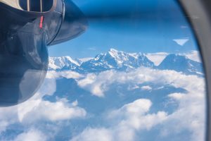
Fortunately, we had spectacular pilots! I was absolutely impressed by their maneuvering against the strong Himalayan winds. During the short 20 minute ride, I could see Everest and many of the other snow covered summits (Ama Dablam, Nuptse, Lohtse, etc) peeking through the clouds. It was just a taste of the beauty and majesty of the Himalayan landscape. When I felt the plane shift into descent, I became a bit nervous about the difficult landing process for Lukla. But our pilots were experienced professionals. The minute the plane touched down, they threw every brake on, flipped the ailerons down, and switched the spoilers up—all in an effort to create enough drag to slow us down before smashing against the rock wall at the end of the runway. We stopped about 20 feet short of the wall and taxied over to a small holding facility to retrieve our bags and head inside for tea and our days briefing.

The Himalayan peaks poking through the cloudy sky.

The pilots shifting into descent and preparing to land at the world’s most dangerous airport—Lukla.

The runway at Lukla—you can see the absolute drop off at the end.
Drastic Change
As soon as I stepped outside of the plane in Lukla, I felt the cool mountain air against my skin. Wearing shorts and a t-shirt worked in Kathmandu, but it was far too chilly for that in Lukla! When we originally took off, we were surrounded by bright reddish ran dirt and palm trees, baking in 80°F heat under the hot sun. Upon landing in Lukla, were reached the alpine zone and were now surrounded by deep green pines, misty skies, and strong Himalayan winds. It felt like I jumped from summer to fall in a matter of minutes. This was the mountains!

The drastic change in landscape—reaching the alpine zone in Lukla.

My roommate, Darcy, and I walking through the streets of Lukla.
Surya and Biru
After landing in Lukla, we enjoyed a bit of tea and met our assistant guides—Surya and Biru. They would be paramount to leading our group, answering our questions, and assisting Ram throughout our time in the Himalayas. Surya was a 25-year-old born and raised in Lukla. He, much like Ram, knew English very well. It seems he had made a name for himself in the community as a strong assistant, working his way from porter to guide in half the time it normally takes. An incredibly intelligent young fella, Surya was the brains of our operation.
Biru, on the other hand, knew very little English. A 27-year-old from a small village about two days walk from Lukla (the name escapes me), Biru became the brawn of the team. Despite the language barrier, he communicated with us well. He led our chain of hikers into the thick of the unknown and through the mountains with incredible speed and determination. Nepalis tend to use “the” before words in unnecessary places. As a result, Ram often began our treks each morning by exclaiming, “Follow the Biru!” For this reason, he affectionately became known as “The Biru.” Many of the guys, in awe of Biru’s speed and strength, would say, “You don’t earn a ‘the’ at the beginning of your name for no reason!”

The Biru, chilling during a rest break on the way to Dingboche.

Following the Biru was easy thanks to his bright orange pack.

Surya, undoubtedly the brains of our trek.
Beginning the Journey
Immediately after meeting Surya and Biru, we began our long journey on the trail. Over the course of our 14 days, we would travel on foot from Lukla all the way to Base Camp, going village to village and staying in local tea houses along the way. In total, it was over 100 miles of trekking and about 9,000 feet of elevation gain. That kind of distance with a camera, extra lenses, and other gear on your back, plus the drain of thinning oxygen at altitude, made for long and exhausting days. Thankfully, we didn’t carry everything ourselves. Local porters were hired by our guiding company, Intrepid, to carry our larger items inside a duffel bag. At first, I felt guilty that someone else was carrying my heavy items. Over time, however, I realized that the mountain economy depends heavily on the use of porters. By paying them to carry my items, I was supporting the local economic system.
Precautions for Altitude Sickness
Because we traveled from just over 9,000 feet in Lukla to about 17,500 feet at Base Camp, acclimatization was key to maintaining our health. Hike too fast and we risked getting sick. For this reason, our trek was extended over a longer period of time, allowing our bodies to slowly get used to the altitude. Unfortunately, natural acclimatization can take many months, so everyone also took Diamox—a medication that causes you to take deeper and longer breaths in order to sustain oxygen levels. Without these precautions, we might find ourselves with Acute Mountain Sickness (AMS)—which begins with simple headaches, nausea, lack of appetite, and fatigue, but can ultimately prove life threatening. The entirely of the trip, we had to be on guard against AMS, ensuring that we didn’t try to “tough it out” but instead paced ourselves to retain good health.
Our Route
While I plan to go into detail about the major villages and what each was like in future posts, this is a basic breakdown of our route:
Day 1: Lukla to Phakding
Distance: 5 miles
Elevation Change: 660ft descent
Day 2: Phakding to Namche Bazar
Distance: 6 miles
Elevation Change: 2,625ft ascent
Day 3: Acclimatization Day in Namche Bazar
Distance: 4 miles
Elevation Change: 1,312ft ascent
Day 4: Namche Bazar to Phortse
Distance: 7.5 miles
Elevation Change: 1,312ft ascent
Day 5: Phortse to Dingboche
Distance: 7.5 miles
Elevation Change: 1,970ft ascent
Day 6: Acclimitization Day in Dingboche
Distance: 4 miles
Elevation Change: 660ft ascent
Day 7: Dingboche to Lobuche
Distance: 5 miles
Elevation Change: 660ft ascent
Day 8: Lobuche to Base Camp to Gorak Shep
Distance: 5.5 miles
Elevation Change: 1,312ft ascent
Day 9: Gorak Shep to Kala Patthar to Osho
Distance: 14 miles
Elevation Change: 1,200ft ascent + 5,250ft descent
Day 10: Osho to Tengboche
Distance: 5 miles
Elevation Change: 820ft descent
Day 11: Tengboche to Chumoa
Distance: 9 miles
Elevation Change: 3,280ft decent
Day 12: Chumoa to Lukla
Distance: 5.5 miles
Elevation Change: 1,640ft descent + 1,640ft ascent
As one might imagine, this was a tough schedule. Most days consisted of early morning breakfast around 7:00am, then we would pack up our stuff, fill up our water for the day (which required lots of filtration and adding purification tablets), trek for about 5 to 8 hours, settle into the next tea house, eat dinner, and finally go to bed to start it all again the next morning. This left very little free time other than a few minutes after dinner. By that point everyone was normally so exhausted that we headed straight for bed. There has never been another time in my life that I found myself going to bed at 7:00pm!
My Next Posts
Despite the challenges and strain of trekking, the experience was equally peaceful and pleasant. In part, it was nice to get out in nature, but it was especially interesting to see how the villages and people in the Himalayas operated. In my future posts, I will detail the many things I learned about the deep mountain communities—as well as my potential thoughts on how the system might be capable of improving. There is much to unpack and I look forward to sharing it all!